The Thomes Creek project consists of test excavations on three sites (CA-TEH-256, -26 , and -262) located on the north bank of Thomes Creek approximately two miles east and one mile north of Richfield, Tehama County, California. The sites are located in Township 25N Range 2W, in a Spanish land grant lacking section designations.
The history of the Thomas Creek project begins in 1963, when Dr. A.E. Treganza directed a survey of the Tehama Colusa Canal, starting at Red Bluff and continuing into Colusa County. Completion of the final report of the survey and subsequent salvage excavation was delayed several years because of the director's illness (Treganza, Edwards, and King 1967). In the interim, modifications had been made affecting the canal location and additional plans were developed for the ancillary construction of a reservoir and a fish canal affecting areas not covered by the original survey. A supplementary survey was made in August, 1967, which found that the new construction, project for the spring of 1968, would destroy one archaeological site and damage several others on the north bank of Thomes Creek (Edwards 1967). Plans were made to initiate salvage excavations at the earliest possible date.
The salvage project had as its main objective extension of knowledge of the Northern Sacramento Valley prehistory back beyond the protohistoric, and definition of the possible economic base and trade relations of the area. A secondary objective was the testing of the effectiveness of pH sampling for discovery of cultural activities within an aboriginal site. The discussion of this objective will be found in Appendix B.
A culture earlier than that known from ethnographic sources was suggested on the basis of data recovered by the survey (Edwards 1967). The most significant elements here were handstones (manos) and millingstones which are not known ethnographically for the Wintun of this area who used the mortar and pestle.
The above objective as well as the limitations of time and cold weather caused the use of the following excavation techniques. Units of 1 x 2 meters were excavated manually using shovels, picks, and trowels. Midden was passed through 1/4 inch mesh screen in all areas except features and burials where 1/8 inch mesh was used. Based on previous experience in this area where natural stratigraphy was lacking, units were excavated in arbitrary levels of 10 centimeters measuring from a northwest corner datum. All units were excavated to sterile manually except the area below one extensive rock feature at CA-TEH-256 where at the end of the excavation the area below the rock feature was explored mechanically. Burial Two of CA-TEH-262 was partially exposed by a power front loader as was a small feature in CA-TEH-261.
Excavation was conducted from December 15, 1967 to January 1, 1968. Cold weather, snow, and high wind were balanced by volunteer assistance so that approximately 85 man-days were effectively expended in the field. A total of approximately 700 artifacts was recovered. Thirty-eight cubic meters were excavated manually with additional exploration by mechanical means of 20 cubic meters.
ECOLOGICAL BACKGROUND
The Thomes Creek area shares the Mediterranean climate of California, with winter rains and summer droughts. The western portion of the Sacramento Valley is in the rain shadow of the Coast Range and receives 21+ inches of annual precipitation. Rainfall in the foothills, in contrast, reaches 60-70 inches annually. The average annual temperature at Red Bluff is 63 degrees F. The summers are hot, with daily maximum temperature in the Valley at approximately 100 degrees F in July. In January, the daily minimum temperature is in the upper 30s. In general, north-westerly winds prevail in summer and south-easterly winds prevail in winter.
The vegetation in this area has been changed drastically with the appearance of the white man.
What vegetation remains at the present time is either second growth or badly disturbed by burning or grazing due to white man's activities. Native California grasses have been almost totally replaced by exotic species which better tolerate heavy grazing . . . much oak forest has been removed for firewood and lumber [Shalford 1963:238].
Originally, the Valley was a parkland covered by oaks and native grasses (Bryant 1936). Large oak groves grew along streams, such as Thomes Creek, extending into the valley flatlands and mixing with the grasses and forbs.1 Growing immediately next to the stream beds were sycamores, elders, willows, berries, and grapes; much of this growth has survived into present times because of its inaccessibility to farming.
The native animal life has also responded to the alteration of the environment. Most predators, except the coyote (Canis latrans) are now extinct, but the number of deer (F. odocoileus), rabbits (F. lagomorpha), and various rodents has increased. Also vanished are the large game animals that once roamed this area, such as the dwarf tule elk Cervus mannodes) and pronghorn antelope (Antilocapra americanus). During the 1963 survey a ring-tailed cat Bassariscus astytus) was observed (Treganza, Edwards, and King 1967). Although the Sacramento Valley has always been a major wintering and breeding ground for the migratory water fowl, they are not mentioned in the ethnographic literature as a large food resource.
ETHNOGRAPHIC BACKGROUND
Very little is known about the River Wintun people who inhabited the Thomes Creek area. They were largely decimated by the epidemic of 1833 (Cook 1943).
The first settler in the immediate area was Robert Hasty Thomes for whom Thomes Creek is named. Land was granted to him in 1844 by the Mexicans. It consisted of five square leagues of land south of Elder Creek on the west side of the Sacramento River. By 1849, Tehama, founded by Thomes, was a boom town (Hisken 1948). By 1851, the whites were demanding that the Indians be removed.
The Indians were seen and recorded ethnographically in their own area only briefly by artist Henry Brown and Major Redding of an Army exploratory force in 1851. The records made of them include brief reports, sketches, word lists, and maps which define the boundaries of the River Wintun people as Red Bank Creek on the north, Stony Creek on the south, and the Sierra and North Coast Range foothills (Merriam 1966). Major Redding recorded a village called "Tehama" between Thomes Creek and Elder Creek, which was also shown by Kroeber (1932) in approximately the same place. Kroeber also mentioned a village called "Olwenem" near the mouth of Thomes Creek but did not give the exact location (1932:265).
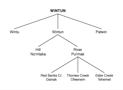
The Wintun-speaking peoples of the Penutian language family were located in the northern half of the state. They were divided into three groups according to dialectical and cultural differences. The northernmost of these groups was the Wintu; the central group was the Wintun proper, and the southern group was the Patwin. Each of these three groups was further subdivided on the basis of minor geographic, cultural, and dialectical differences. The boundaries between these groups, however, tended not to be sharply delineated.
The territory of the Wintun was the west side of the Sacramento Valley from the river up to the crest of the Coast Range. The Wintu occupied that part of the territory which includes the Trinity, McCloud, and Pit Rivers, as far south as Cottonwood Creek. The central Wintun extended from Cottonwood Creek to the present town of Willows on both sides of the Sacramento River. The Wintun were further divided into the hill and river peoples. The Patwin held the remainder of the territory south to San Francisco Bay.
As the Nomlaki (the Hill Wintun) were named by the River Wintun ("No'mlaka") (Kroeber 1932:355), so the River Wintun will be designated herein by the Nomlaki term "Pui'mak." Hereafter the two major branches of the Central Wintun people to be found in the area under discussion will be described as the Nomlaki and the Pui'mak, the latter including the Thomes Creek tribelet of Olwenem (see Chart 1, below).
The Wintun were not a unified political unit such as the Plains Indian tribes. The basic unit was the family, but the village or tribelet as defined by Kroeber (1932) was the social, political, and economic unit. Among the Wintu a village would usually be located on a flat near the bank of a stream and might be composed of a dozen or fifteen bark houses and an early lodge (Dubois 1935). The Wintun equivalent was composed of brush shelters arranged about and facing a chief's house. The chief's house was the center for many group activities: gambling, smoking, storytelling, and sweating dances. A menstrual hut was placed on the side of the village opposite the water source. In historic times, a large, multipost dance house was located off to one side, usually at some distance (McKern 1923). Village populations for the Wintun have been estimated as ranging from 20 to 200, with small camps often located within calling distance of each other. In the winter, the village was the permanent camp, but during the summer it was deserted for a temporary camp elsewhere (Goldschmidt 1951).
While the patterns of season population movement of the foothill groups of California are fairly well documented, the demographic patterns of the valley groups are not so clear. Kroeber (1925) indicates that although nomadic, the Sacramento Valley people appeared to be entirely confined to the valley floor, having little social interaction with the hill groups. He notes "the almost perfect correspondence between topographic and speech boundaries. Lines of dialectic cleavage followed the edge of the plains in the (greater) Sacramento Valley" (1925:487). The settlement pattern of the Pui'mak seems most analogous (based on environmental similarities) to that of the Valley Yokuts, described by Kroeber as follows:
Valley peoples evidently had their permanent villages on the river itself--that is in the marsh belt (or next to it), but appear to have left this during the dry half of the year to live on the adjacent plains--mostly by the sides of tributaries [1925:354].
Chieftainship was in theory hereditary, descending from father to son, but in practice, a desirable personality and qualifications were more important criteria than descent. The chief was a leader, not a ruler. His main duties were to advise and direct his followers, which necessitated his being a "good talker"--one of the prime requisites of his office. His second major function was that of arbiter. He also filled an important role as economic stabilizer through his trading with other groups and by maintaining an equal food supply throughout the village by storage and redistribution. Every major village would probably have such a chief, although a sub-area, including several small villages, might fall under the influence of a single leader. Such a sphere of influence was in no way formalized, and the number of chiefs depended on the size of the population and the number of able persons. The chief received prestige from his personal qualifications and from his wealth. His position also exempted him from arduous manual labor (DuBois 1935).
The Wintun and the Patwin used shell beads as money. These were strung, and the string often measured from finger tips to shoulder. The most popular beads, obtained from the Pomo and Coast Miwok, were made from clam shells usually roughed out or in finished bead form. The Wintu also used clamshell beads as money, but counted them as coins rather than measuring them by the string length. Dentalium shells traded from northern neighbors were prized to a lesser extent, as ornaments rather than money. Magnesite cylinders were used by all the Wintun; these were rare and greatly valued.
Within the community, trading often took the form of gift-giving. The presentation of a gift was done with the understanding that its equivalent would be returned in the near future. This practice was the basis for a north-south trade chain that connected the various Wintun sub-areas and extended from San Francisco Bay to the Shasta territory. Clamshell disks came from the south and were exchanged for the superior obsidian, pelts, and yew wood of the north. The Wintu, however, usually procured their own obsidian on peaceful expeditions to Glass Mountain.
In view of the Pui'mak geographic position on the river, it is not surprising that fish, especially salmon, were a major trade item. Salmon and river animals were traded with the foothill Nomlaki in exchange for pine nuts, acorns, mountain seeds, and mountain animals. The exchange was not in terms of straight barter, but by purchase with shell money and valuables, such as magnesite. With the same currency used in the extensive north-south trade route, a rather well-developed pricing system appears to have emerged, as noted by Kroeber: "They did have an unusually exact set of shell bead valuations for property of various kinds" (1932:422).
Birth, puberty, marriage, and death were important ritual occasions among the Wintun. When a girl reached puberty, she was confined to a specially erected menstrual hut and, if of a wealthy or prestigious family, a dance would be held in her honor. A woman was confined to the menstrual hut each month thereafter by the Wintu. The Nomlaki did not require this, but numerous ritual prohibitions regulated conduct among both groups during the "dangerous time."
Marriage was a rather casual relationship among the Wintun. Monogamy was the rule, and divorce easy. The Nomlaki practiced village exogamy.
As a rule, the Wintun buried their dead, although some cremation may have been practiced by the southern Patwin. Cemeteries were located about 100 yards from the Wintu village, as compared with 300 to 400 yards among the Nomlaki, where they were sometimes shared by several villages. To make a grave, a round hole was dug to a depth of three to four feet. The body was tightly flexed, wrapped in a black bear pelt (if available--such pelts were highly valued for this purpose), and then bound with ropes or nets. It was dropped into the grave, accompanied by much wailing and mourning. This interment method rather precluded any directional orientation of the body. An individual's personal belongings and wealth were interred with him or burned. People who did not sacrifice a relation's belongings were seen as caring more about his valuables than about him or his memory. Widows often cut their hair and rubbed pitch or tar into their scalps. It was left on until it wore off.
The Wintun were fond of contests involving physical skills and prowess, such as races, football, hockey, and shinny. They were also fond of gambling, which often took the form of hand games.
During the proto-historic period, there was in central California a widespread socio-religious cult system known as the Kuksu or "Bighead" Cult (Barrett 1919). The Wintun practiced Kuksu only in the valley areas near the Sacramento River and adjacent to the Patwin. Among the Wintu it was completely absent. It was, however, found among the Patwin, Maidu, Miwok, the northerly Yokuts, Pomo, Yuki, Coast Miwok, Costanoan, Esselen, and Salinan.
Kuksu was a cult associated with men's secret societies. Women seldom participated. It consisted of ceremonial assemblages at which dances were held. During the dances selected cult members disguised themselves with paint and elaborate head-dresses (from which came the name "Big-head") and performed ritual dance impersonations of spirits. The specialized knowledge needed to perform the various dances was closely guarded. It was passed on to a man as he reached increasingly higher levels in the society. Each village had its own Kuksu Cult and leader, who enjoyed honor and prestige. Not all men were allowed to participate.
Cult ceremonies were held in large semi-subterranean structures known as dance houses or lut. These were usually found only in the larger villages. They served partially as sweat houses and men's lodges, but were mainly intended as Kuksu lodges. A typical Patwin dance house was 20 to 40 feet in diameter and four feet deep. A fire pit was in the center. East and west of the fire stood two main support posts for the earth-covered log and brush roof. Eight secondary posts were located nor far from these walls. Rafters were laid out from the center posts to the outer ones, and then to the ground. There were two entrances--the main door to the east and the rear door to the west. A ramp was cut from ground level to the front door. In front of the rear door was a footdrum, a log over a hollow in the floor that was stamped with the feet (Barrett 1919).
The Wintun also had dance houses, even where the Kuksu Cult did not spread. Their dance houses were quite like those of the Patwin. Entry ramps were often roofed over.
ARCHAEOLOGICAL BACKGROUND
[in progress]
END NOTES
1 Forb -- any herb that is not a grass or grass-like.
2 An excellent ethnobotanical study of the upper drainage of Thomes Creek has been done by Kerry Chartkoff, UCLA, as an appendix to Chartkoff and Childress (1966).
REFERENCES
Elsasser, A.B. 1960. The Archaeology of the Sierra Nevada in California and Nevada. Reports of the University of California Archaeological Survey 51.
Gifford, E.W. 1932. The Northfork Mono. University of California Publications in American Archaeology and Ethnology 31(2).
Heizer, R.F. and A.E. Treganza. 1944. Mines and Quarries of the Indians of California. California Journal of Mines and Geology 40(3):291-359.
Hindes, M.G. 1959. A Report on Indians Sites and Trails, Huntington Lake Region, California. Reports of the University of California Archaeological Survey 48:1-31.